
The myth of the “One Hundred Year Flood” continues as FEMA maps both the 100 and the 500 year flood without any reference whatsoever to actual flood records. Today people are building houses in areas that are outside the “100-year flood zone” only to get inundated with water in their houses a few years later.
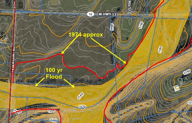
Below is the 100 year flood map in yellow. But from my personal observation at the time of the 1974 flood, I can safely say the water was at least this high. When designed about 1950, the bridge height above the stream would have been sit to be at least 3′ higher than the highest anticipated flood at the time (called “Freeboard.”) In fact, the water was 2′ over the banisters and at least 6 or more feet higher than the bottom of the bridge. So its design height was inadequate by at least 6′. Were the bridge replaced now, it would almost certainly be raised several feet and the approach from the east likewise raised as well as relief culverts placed under the road, or the bridge extended over a portion of the dry ground.
Yes, development in the watershed can cause that. But reality is that history, some of which is not recorded; in fact, MOST of history does not record these events.
And it would be rather meaningless if it did. Climates change and we know that almost all areas see climatic changes over the span of thousands of years. The Ice Ages are well documented, and ice began to retreat some 15,000 years ago after peaking 50,000 years ago. At times the plains of Oklahoma were a dry tundra land and the Ozarks were devoid of any trees. Ancient landslides are common in the southern Ozarks north of the Arkansas River.
The Mississippi River hugged the Ozarks and used what is now the White River as a channel while the Ohio turned south and was, in effect, the Yazoo of Mississippi. The “muddy” Miss was, in fact, much muddier take the detritus of the edge of the retreating ice sheets and redistributing it in the delta flatland.
Near the town of Gentry, Arkansas, Flint Creek is a small and unassuming clear water creek that rarely floods but in 1974 a storm lasting some 8 hours dumped 14” of rain on the watershed. The resulting flood caused bridges to be over-topped on Hwy. 12 near Springtown and washed out roads and bridges over a large portion of the western part of the county. As a personal witness, I was unable to return home and sat out the storm on the west side of that Hwy. 12 bridge. Water reached 2’ or so over the banisters of the bridge and did not recede until nearly dark. But today’s flood maps do not show that on the 100 year flood.
So how frequently does this happen? Every 100 years? According to one old timer, who like me, was unable to return home, he recalled that a similar flood occurred in 1927, a year famous for flooding the entire Mississippi River basin. And historically, 1892 saw a flood so large it flooded downtown Siloam Springs, washing away a small doctor’s private office-home killing him, his wife, and his nurse. In other words, these floods were occurring 3 times in less than one hundred years. So much for maps.
FEMA tries to explain that the 100 year flood is a misnomer, and only means a 1 in 100 chance of a flood in any given year. So a word of warning. If you are near a creek, buy flood insurance you never know what will happen.